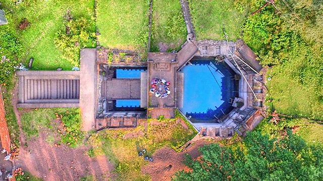
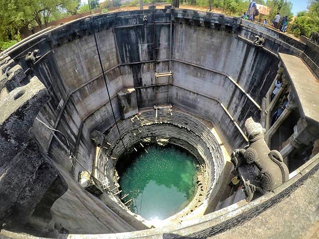
Baramotichi Vihir is a stepwell in 'Limb', Satara village in Satara district in the Indian state of Maharashtra . It was constructed between 1719 and 1724 by Virubai Bhosale (a secondery wife of Chatrapati Shahu Maharaj) to supply water to some 300 nearby mango plantations. It is 110 ft deep and 50 ft in diameter. Limb village is situated around 16 km from Satara and approximately 99 km from Pune. Design : The well is octagonal and looks like a dug-out Shivling. The entire structure of the stepwell is made of black stone. With its 12 moats, it was meant to be a water source to the surrounding farms. It was also utilized to relieve the overflow of water during monsoon times. From the top, visitors can see a few tiny walls and water channels. Various old statues and historical structures are found in this well. Mahal is also situated there |
 |
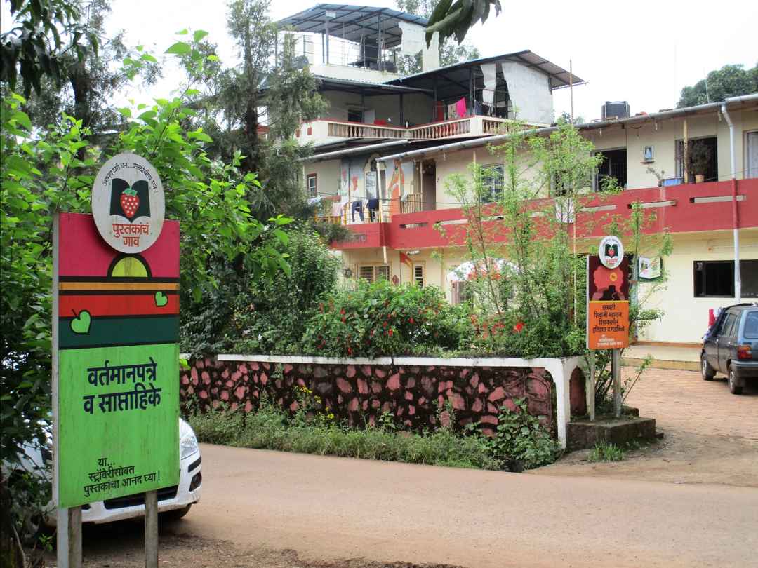
Pustakanch Gaav (English: Village of Books) is a special library in Bhilar, Maharashtra that opened on May 4, 2017. The initiative was conceptualized and led by Vinod Tawde, Minister of Cultural Affairs and Marathi Language and inaugurated by Devendra Fadnavis, Ex.Chief Minister of Maharashtra. This government initiative is inspired by Britain’s Hay-on-Wye, a notable Welsh town known for its book stores. At the time of launch, there were 25 artistically decorated locations in Bhilar that are turned into spots for readers; collectively they housed over 15,000 books in 18 distinct genres. Most books were in Marathi language and there were plans to add additional 25,000 books in other languages such as English, Hindi and Gujarati. On 2021 June 19, Perumkulam, a village in Kerala’sKollam district, was declared a Pusthaka Gramam (village of books) by Kerala Chief Minister Pinarayi Vijayan. The announcement made on June 19, National Reading Day, makes it Kerala’s first such village. At the heart of the announcement is its library, Bapuji Smaraka Vayanasala. Location: Spread over two kilometers, Bhilar is located at a distance of eight kilometers from Panchgani. It is situated just about 17 kilometers away from the sub-district headquarter Mahabaleshwar, which is a notable tourist spot in Maharashtra. Other major cities around Bhilar include Satara, Pune and Mumbai. Bhilar has an estimated population of 5,000 and is a major producing hub of strawberries. Pustakanch Gaav is accessible by road, rail and air transport. Road -There are various private buses, cabs and taxi services from Pune and Mumbai. Bhilar village is only 17 km from Mahabaleshwar. Rail -The nearest railway station is Satara which is 56 kilometers away from Bhilar. Nearest major railway junctions include Pune (148 km) and Miraj (188 km). Air -The nearest airport is Pune International Airport, which is about 118 km from Bhilar. Chhatrapati Shivaji International Airport of Mumbai is 259 km away. |
 |
Panchgani, called Paachgani is a hill station and municipal council in Satara district in Maharashtra, India. Panchgani attracts many tourists throughout the year. It is also renowned for many premier residential educational institutions. Panchgani is around 108 kilometres from Pune and 250 kilometres from Mumbai. Panchgani is nestled in the middle of five hills in the Sahyādri mountain ranges. There are five villages around Panchgani named Dandeghar, Khingar, Godavali, Ambral & Taighat. The Krishnā River flows in the valley on which the Dhom Dam has been built approximately 9 km from Wai. The east of the Panchgani is Wai, Bavdhan & Nagewadi dam, at west is Gureghar, at the south is Khingar & Rajpuri & on the north is Dhom Dam. The five hills surrounding Panchgani are topped by a volcanic plateau, which is the second highest in Asia after the Tibet Plateau. These plateaus, alternatively known as table land, are a part of the Deccan Plateau, they were raised by pressure between the earth plates. The area has high seismic activity, with an epicenter near Koynānagar where the Koynanagar Dam and a hydroelectric power plant have been built.
|
 |
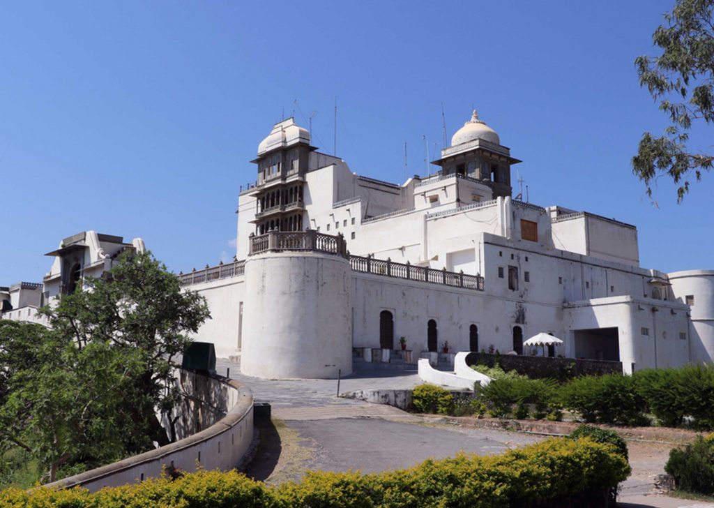
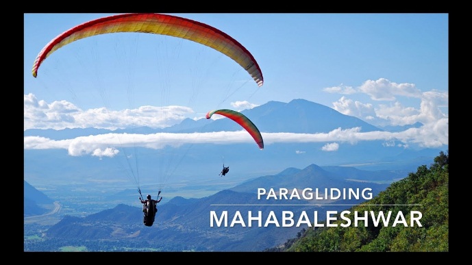
Mahabaleshwar (pronunciation) is a small town and a municipal council in Satara district, Maharashtra, India. It is a place of pilgrimage for Hindus because Krishna river has its origin here.[1] The British colonial rulers developed the town as a hill station, and served as the summer capital of Bombay Presidency during the British Raj. Mahabaleshwar is located on the mountainous Sahyadri range of the Western ghats that run North to south along western coast of India. The coordinates of the town are 17.9250°N 73.6575°E.[2] Mahabaleshwar is a vast plateau measuring 150 km2 (58 sq mi), bound by valleys on all sides. It reaches a height of 1,439 m (4,721 ft) at its highest peak above sea level, known as Wilson/Sunrise Point The town is about 122 km (76 mi) southwest of Pune and 285 km (177 mi) from Mumbai, Mahabaleshwar comprises three villages: Malcolm Peth, Old Kshetra Mahabaleshwar and part of the Shindola village.Mahabaleshwar region is the source of the Krishna River that flows across Maharashtra, Karnataka, Telangana and Andhra Pradesh. The legendary source of the river is a spout from the mouth of a statue of a cow in the ancient temple of Mahadev in Old Mahabaleshwar. Legend has it that Krishna is Lord Vishnu himself as a result of a curse on the trimurti by Savitri. Also, its tributaries Venna and Koyna are said to be Lord Shiva and Lord Brahma themselves. 3 other rivers come out from the cow's mouth apart from Krishna and they all travel some distance before merging into Krishna which flows East towards the Bay of Bengal.[3] These rivers are the Koyna, Venna (Veni) and Gayatri. The Savitri river flows Westward via Mahad to the Arabian Sea.Climate of the area is suitable for cultivation of strawberries, Mahabaleshwar strawberry contributes to about 85 percent of the total strawberry production in the country.[4][5][6][7] It also received the geographical indication (GI) tag in 2010. Road-Mahabaleshwar is 32 km from Wai. It is 260 km from Mumbai, the state capital. The nearest major city is Satara, 45 km and it is 120 km from Pune and 263 km from Mumbai thane Mahabaleshwar is connected by the National Highway 4. Bus services by state-run MSRTC and private organizations connect it to Pune, Mumbai, Sangli and Satara. Rail-Nearest railroad is Satara, 60 km. Nearby major railway junctions include Pune (120 km), and Miraj (170 km) . State-run bus services are available in these locations to Mahabaleshwar. Rail station Diwan Khavati on Kokan Railway near Khed gives a route of 60 km via Poladpur to Mahabaleshwar. Air-The nearest airport is Pune International Airport, serving the city of Pune, 120 km from Mahabaleshwar. Chhatrapati Shivaji Maharaj International Airport of Mumbai is 270 km |
 |
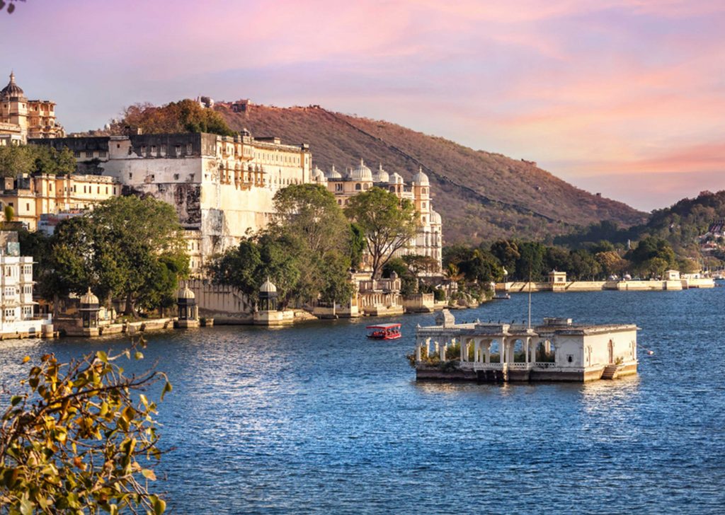
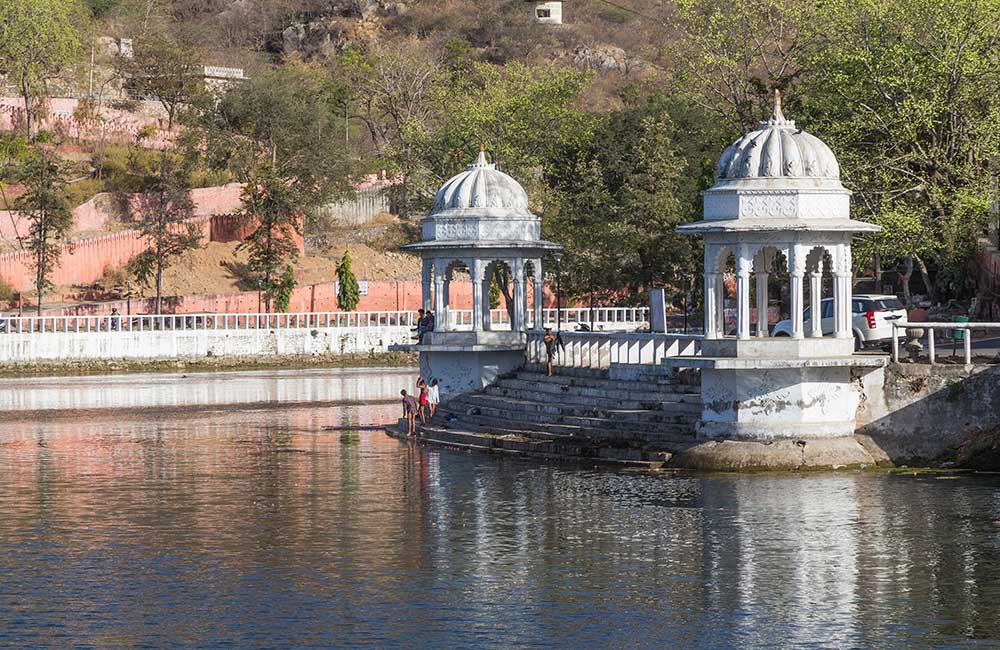
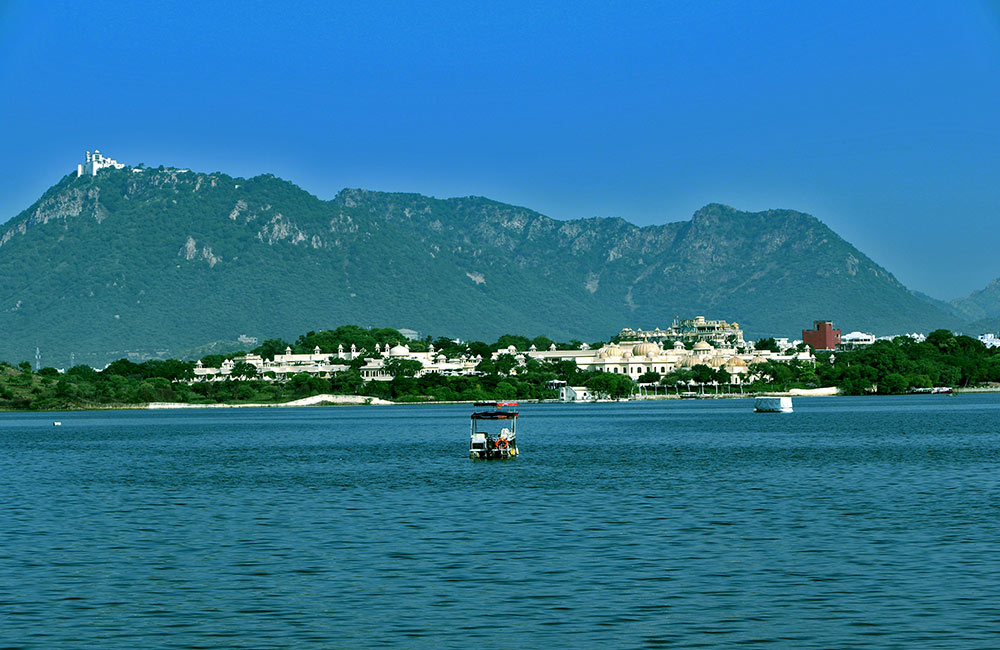
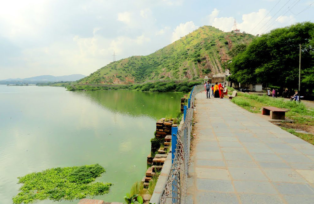
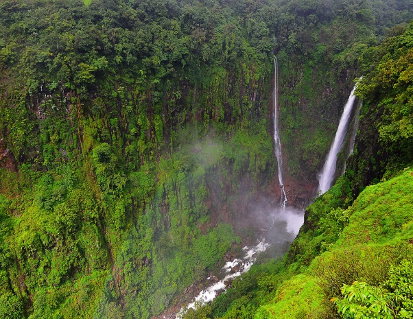
The Kas plateau is approximately 22 kilometers west of Satara. Kas lake on this plateau supplies water to Satara city. Numerous types of wildflowers bloom on this plateau after the onset of monsoon. The plateau was included in the protected list of UNESCO World Heritage Sites in 2012 due to many rare species found here. Kas Plateau is a tourist destination. Kas is a biodiversity hotspot. The plateau is famous for the variety of wildflowers and butterflies that bloom on it from August to October. The elevation of the plateau ranges from 1000 to 1250 m above sea level, and the area is approximately 10 sq km. The plateau is home to 280 species of flowers and 850 species including vines, shrubs and other species. 39 out of 280 flower species in the IUCN regional red list (a list of regional species declared as threatened by the International Union for Conservation of Nature and Natural Resources) are found here. Around 59 species of reptiles (reptiles) are found here. Bhambvali Flower Plateau - The largest flower plateau in the world. This plateau is just 3 km from Kas plateau and falls in 3 taluks, Satara, Jawli and Patan. However, this floral plateau, blooming with colorful flowers, has remained far from the eyes of tourists, neglected. Satara has been blessed by nature. Kas-Bhambvali-Tapola-Mahabaleshwar-Patan area is covered with evergreen forest. The hilly area of the same Western Ghats is home to Koyne's Shivsagar Reservoir, Bhambvali, Vajra Waterfall, the UNESCO-listed Kas Pushpa Plateau, as well as forts/forts like Pratapgad. Tourists experience authentic biodiversity in this evergreen forest. Pushpa Plateau of Kas, Chalkewadi Windmill Plateau, Tablelad of Panchgani are called Sada Plateaus. During the rainy season, grass grows on this sada and colorful flowers start swaying on it. No road, no cars, no tourists, so no pollution. Here the domestic animals of the surrounding villages graze contentedly. Similarly, as there is no fence, wild animals roam freely. There is no human disturbance, so the life cycle of nature continues unhindered. Grass and flowers get dung and urine. Therefore, the grass and flowers here grow vigorously. This colorful festival of nature starts in July and can be seen till September. In September, the entire plateau of Bhambvali is seen blooming with various colors. It is as if the temple of nature goddess is bursting with colors. The flower plateau of Bhambvali is dry in summer. The blooming of flowers on the Kalakutta purple stone plateau is a great surprise during monsoons. Multicolored flowers on stone is a miracle of nature. Interestingly, colorful crabs are seen roaming on this plateau only on Dussehra day. Footprints of the Pandavas of Vijanvasa can be seen (so it is said) on this plateau. Kas can be reached from Satara. Next to the Kas temple is the Ranli Phata, 3 km from there is the rehabilitated Tambi Vasti. After climbing a 500 meter climb from Tambi, one can reach Bhambwali Sadya. Coming to this plateau feels like reaching the highest point in the area. There is silence on this plateau. There is perennial cold wind. Here it is like the power of the wind. A gentle breeze, its own tune and its own song. A sweater is a must because of the cold. Sajjangarh, Urmodi Reservoir can be seen on the east side of Bhambvali Plateau while Shivsagar Reservoir of Koyne, Vasota Fort is a densely forested hill on the west side; The triple confluence of Koyna, Solshi and Kandati rivers can be seen. To the north is the Kas Pushpa Plateau and to the south is the Windmill Plateau of Chalkewadi. All this can be seen and felt from the same floral plateau of Bhambvali. Along with the company of nature, wildlife can also be seen on this plateau. Sheep, rabbits are seen running in the distance. Ferocious animals like leopards, bears also come to the plateau. So tourists need to be careful. The plateau is slippery at many places. So there is a possibility of falling. The plateau is shrouded in thick fog and there are steep slopes on either side of the plateau. Because of thick fog, it is not known that we have reached the ridge, so tourists should be careful. While walking, sometimes the sight of red-yellow gourihara and sometimes the blossoming of red and yellow flowers, everywhere, but in between, the blue-purple flowers of wild basil attract attention. Karvi flowers after seven years. When it blooms, its empire is felt everywhere. It is green for six years. Karvi flowered in 2016. Now it will bloom in 2023. The red-purple Ranapawata or elephant's trunk attracts the mind. On the Kas Plateau, Scorpion, Dudhli, Ran Bhendi, Morning Glory, Atibala, Ranakpas, Godkhi, Khulkhula, Sonki, Red-white Gunj, Bawchi, Satara Terda, Ran Jasvand, Indigo, Chanch, Ekkadni, Gulab Bahul, Kerala, Mustard, White Midday , Cassia, Durangi Atibala, Linseed, Ran-Kale Teel, Nisurdi, Dhamana, Supari flower, Aboli, Flax, Kate-Koranti, Samudravel, Moticanch, Ganeshvel, Purple Manjiri, Vishnu Kranti, Pan Laung etc. are 70 types of flowers. During the rainy season, there is a festival of colors on the Bhambvali Pushpa Plateau. There is no interference of the government or hindrance of tourists. Shades of different colors are seen everywhere from the plateau to space. To the south of the Kas Plateau is the Kas Lake. There is a dense forest around Kas lake. It is located between Sajjangarh and Kanher Dam. Koyna project is located 30 km south of Kas lake. Near the lake is the Bhambvali Vajrai waterfall. Near the Kas plateau is the Kumudini lake. The waterfall: At a distance of 13 km from Sajjangad is Toseghar waterfall. Like the Sahyadri hills, Toseghar also has a series of waterfalls. The height of one of the waterfalls is approximately 200 meters. |
 |
The Vithoba Temple, officially known as Shri Vitthal-Rukmini Mandir is a Hindu temple in Pandharpur, in the Indian state of Maharashtra. It is the main centre of worship for Vithoba, a form of the god Vishnu or Krishna, and his consort Rakhumai. The temple was built by King Vishnuvardhana of Hoysala Empire between 1108–1152 CE upon being convinced by the historical figure Pundalik. Also, there is an inscription in the temple, of a Hoysala King Vira Someshwara dating back to 1237 CE, which grants the temple a village for its upkeep. It is the most visited temple in Maharashtra. The Warkaris start marching from their homes to the temple of Pandharpur in groups called Dindi (procession) to reach on Aashadhi Ekadashi and Kartiki Ekadashi. A dip in the holy river Chandrabhaga, on whose banks Pandharpur resides, is believed to have power to wash all sins. All the devotees are allowed to touch the feet of the idol of Vithoba. In May 2014, the temple became the first in India to invite women and people from backward classes as priests. Although parts of the temple date to the 12th or 13th century, the existing structure mainly dates to the 17th century or later, and reflects the later Deccan style, with dome motifs and lobed arches. The main entrance of Lord Vittala's Temple is facing towards the Chandrabhaga or Bhima river. Samadhi of Namadev and Chokamela is at the entrance. Pilgrims will first pray to the Devotees and then enter the temple. A small Ganesh Shrine is present inside the temple as first Shrine. Then, a small hall where bhajans are performed. A small Shrine for Garuda and Hanuman. Then, after climbing a few steps, we can see the face of Lord Vittala. We can have this Mukha Darshan any time without standing in Queue. For, Padha Darshan (To touch the Lotus Feet of Lord), there is an entrance which leads to the queue complex outside the temple. It will lead to many small shrines of Bhaktas, then towards the Lord Panduranga. We can touch the feet of Lord. We feel best when we touch the Lord's Lotus feet. There are Shrines for Rukmini Devi, Satyabhama Devi, Radhika Devi (Rahi), Lord Narasimha, Lord Venkateshwara, Goddess Mahalakshmi, Nagaraj, Ganesha, Annapoorna Devi. There is another mandap where all devotees play like Krishna had played with Gopikas. |
 |
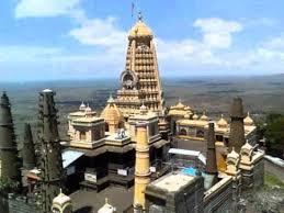
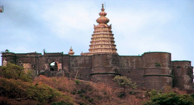
Shikhar shingnapur shiva temple is located in shingnapur hills, near satara district of maharashtra. Its an old temple devoted to lord shiva. Since this temple is located at top (shikhar) of shingnapur hills, thats why it must be called shikhar shingnapur. Two more shiva temples which should be visited by lord shiva devotees and are very near to this temple are amruteshwar temple and guptlinga temple (about 3 km away). The temple is connected with great king shiva ji maharaj family. Shiva ji maharaj used to visit this temple often. |
 |
Shri Bhavani Museum is a gallery situated in the state of Maharashtra. Shri Bhavani Museum is located at a distance of around 43kms from the Satara city centre and 20 kms from the Vaduj. Shri Bhavani Museum was constructed by Raja of Aundh, late Bhawanrao Pantpratinidhi in 1938. The museum showcases the work of Bhawanrao during his lifetime. Shri Bhavani Museum also has the stone figure of 'Mother and Child' by Henry Moore. The museum has four sections entirely devoted to Western paintings that includes Madonna of the Book by Andrea Del Sarto; a Rembrandt self-portrait, In The Prison Of Aurangzeb by A. H. Muller, Beggar Boy by Bartona Morilla, Franciso by L. Goya, Boy Volunteer by G. G. Hierice, Game of Draughts by F. Morelli, Pairs by Cornil. Visitors can ideally spend around two hours, on a visit to Shri Bhavani Museum. Shri Bhavani Museum can be visited during timings 10:00 AM - 5:00 PM. Entry fee is INR 15. The museum remains closed on Mondays and Public Holidays. |
 |